Waterfall on Hickory Branch
Also known as: Hickory Branch Falls
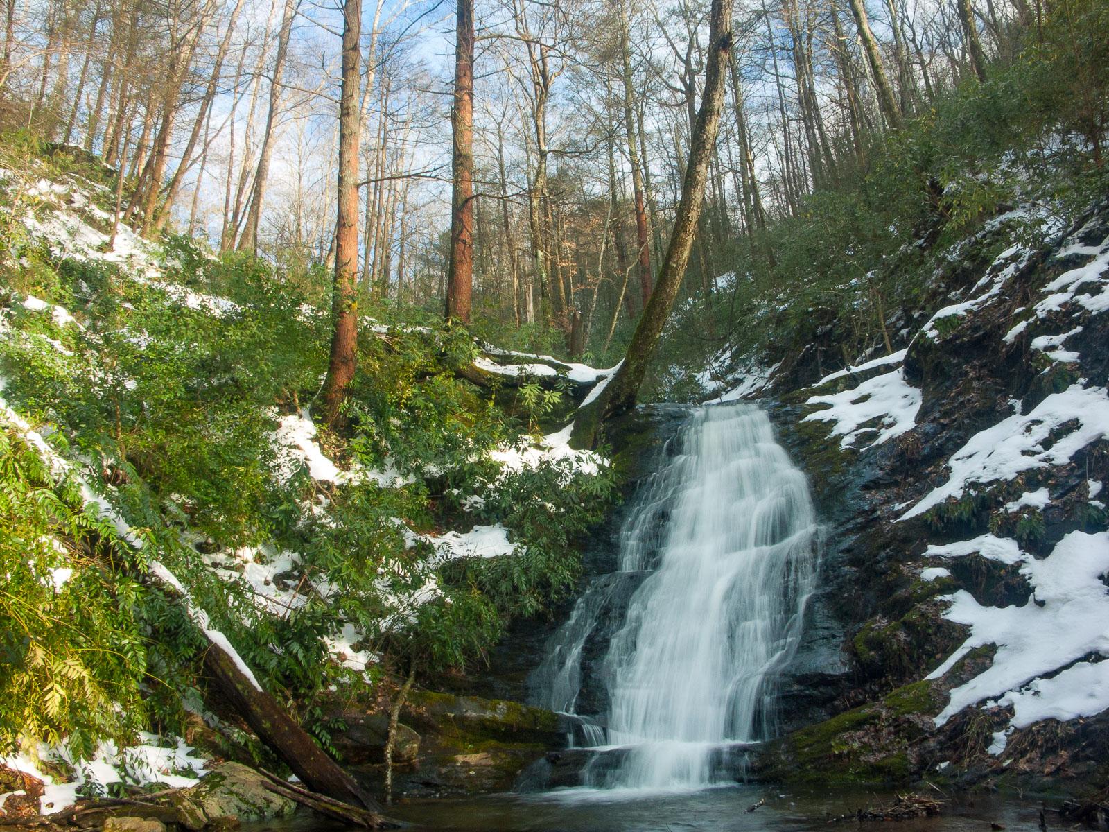
The waterfall is located in the new (as of 2023) Mackey Mountain Recommended Wilderness area in a remote, serene setting. A cascade over curving rock that looks like the illustration for the word "syncline" in a geology textbook, which spills into a small pool. Its left bank is covered with dog hobble and rhododendron, while the right bank is less vegetated.
Statistics
- Height: 30 ft
- Elevation: 2040 ft
- Stream: Hickory Branch
- Landowner: Pisgah National Forest
- GPS: 35.6936, -82.1884
Hike Information
- Difficulty: Moderate
- Length: 1.2 - 2.3mi
- Tread Condition: Some Obstacles
- Climbing: Climbs Moderately (275 ft)
- Type: Out-and-back
Map
GPS Directions & Map
From Current Location or address:
Driving Directions
From Asheville, take I-240 East to I-40 East. Go 18.9 miles and take exit 72 for Old Fort (US Hwy. 70). Go 3 miles, passing through downtown Old Fort, to Curtis Creek Road and turn left. Go 5.1 miles to the Curtis Creek Campground. The trailhead parking is on the left just after the bridge over the creek.
There is a gate about 1/4 miles before the main parking area, just as you start entering the campsites. If it is closed, there is a place to park on the left just before the gate. You'll have to hike another 0.3 miles up the road past the gate to the trailhead if it's closed.
Trail Description
The orange-blazed trail starts across the road from the parking area, on the hill behind campsite #16c. Look for the tall brown stake which serves as the trailhead sign. The trail begins by climbing to the top of the ridge. Don't go straight up; turn left to follow an actual trail around a switchback which comes out in the same spot at the top of the ridge.
Descend the other side of the ridge. The trail is pretty steep here too. At the bottom of the descent, cross Hickory Branch. You should be able to rock-hop this one and stay dry, but it's wide and the creek bottom is soft, so you may wind up soaked in high water. Pick up the trail heading upstream on your right side of the creek (river left).
The trail levels out into a scenic cove. After 0.3 miles from the start, the trail crosses to the left side of the creek, which is usually an easier crossing. After another 0.2 miles it gets steeper and veers left up a steep grade along a drainage to an old logging road. It levels out again, and you'll see the falls on your right shortly thereafter.
From point on the trail where you can see the falls, there is no good way to get to the base. The bank is too steep and you risk hurting yourself and the ecosystem by descending on the thin soil. The view is better from the trail anyway, but if you must go to the base, head back down the trail to the little drainage and descend to the creek where the bank is not as steep. Then, follow the creek upstream to the falls.
About 1/4 mile beyond the falls is an upper waterfall on Hickory Branch. It's about the same height but closed in a bit more with less water. It's worth the extra 1/2 mile round-trip to see it if the water levels are normal to high, and the trail up to it is beautiful either way. It's located on the right at the end of a switchback after crossing a tributary branch.
If the campground is closed and you start at the gate, and hike to the upper falls, that puts the round-trip total at about 2.3 mi.